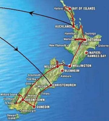
New Zealand's North Island
I had about three weeks left to explore the north of New
Zealand. My way led from New Zealand's capital Wellington into the
active volcanic center around Mt Ruapehu and Mt Tongariro, on to the
geysers of Rotorua, along the subtropical beaches of the Coromandel
Peninsula and the Northland and finally into Auckland, Polynesia's
largest city. |
 |
|
|
Wellington
Arriving on the North Island Wellington showed why it is called the
windy city. Must be a good spot for windsurfing over here.
Unfortunately, I did not have time for that as I had to move on north.
So I went for a bit of sightseeing in New Zealands capital the next day
and visted the national museum Te Papa. The next morning, however, it
was time to get back to nature again and so I took the train to Mt.
Ruapehu and Tongariro NP. |
 |
|
|
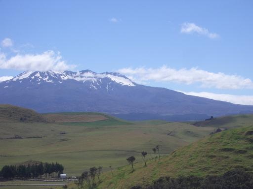
Tongariro Crossing
Leaving Wellington at sunrise, I arrived on the central volcanic
high plateau in the early afternoon. Coming from the south it was quite
clear and I had some nice views of Mount Ruapehu (on the picture), an
active volcano which is the highest elevation of NZ’s North Island.
Originally I wanted to cycle for 60 km up to Turangi but strong winds
and rain approaching from the north west raised doubts in me whether I
could make it there before darkness and so I decided to stay in a
backpackers in the tiny settlement of National Park village.
The next morning a small shuttle bus took me and some others to the
start of the Tongariro Crossing, which is considered to be the best one
day walk in New Zealand. |
 |
|
|
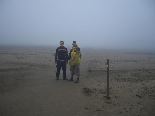
| Unfortunately, the weather forecast did not look very promising
with low clouds and even lower temperatures. But we decided to go on the
track anyway and started the 17 km route with about 20 others that
wanted to take this challenge in spite of the weather. In the first
minutes on the track, small clusters of independent hikers were formed,
mainly depending on the walking speed of the individuals. So I went
alongside another German and two Frenchmen and climbed the first ridge
from about 900 metres above sea level to the South Crater at 1600
metres. Our hopes for getting above cloud base and having these
magnificent views for which the track is also famous for, however, have
not been fulfilled. Instead we climbed deeper and deeper into the clouds
and it just became wetter and, of course, colder, the higher we got. But
it was a very special experience in this rough and mysterious landscape.
|
 |
|
|
| Originally we wanted to take a side track and climb to the summit
of Mount Ngauruhoe. But bad sight and temperatures close to freezing
level forced us to stay on the track. We made our way through the South
Crater and the Red Crater towards the ridge of the Central Crater at
about 1900 metres. In the meantime, the winds had increased to storm
level and it became a challenge, much tougher than all of us had
expected. On our way down the northern slopes we walked alongside the
Emerald Lakes and were able to experience the activity taking place
beneath the ground. The strong smell of sulphur was everywhere and it
became hard to tell which clouds originated from the sky and which ones
from the volcano. |
 |
|
|
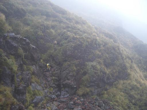
| Following the track we came to a corner with a sign showing: “Hot
springs - Do not enter this area”. Without this sign, we would
never have entered that area since it did not look very promising. But
as we were all very keen to get to a hot spring, we had no choice but to
leave the track. In the rough terrain we did not really know what to
follow and so we orientated on the smell of sulphur and the sound of
water in search of that spring. It became quite steep and rocky as you
can see on one the pictures but we finally found some water running over
rocks that was not boiling hot but it had a comfortable temperature of
30 to 40 degrees. But what was even more impressive were the bright
white, green and red colours which the minerals in the water created on
the rocks. |
 |
|
|
Afterwards, we were happy to discover the track below us on the
slopes of the mountain and when we made our way there it became a more
gentle walk into denser vegetation. Eventually, below 1000 metres we
descended through native rain forest and alongside nice waterfalls to
the end of the track. Over there our shuttle bus brought my bike and I
decided to take it on another bus which was collecting tourists going to
Taupo as I was not able to cycle another 50 km after that exhausting
day.
Skydiving on Lake Taupo
As the end of my time in NZ came closer I could not afford to take
a day of rest and so the next morning I went skydiving at sunrise before
heading the 90 km from Taupo to Rotorua. It was a beautiful morning with
just a few clouds and I was quite confident that I really wanted to go
skydiving. But as I entered the plane and it started to rise in the air,
my nervousity rised as well.
|
 |
|
|
| When we reached 12,000 ft and the first pair jumped out of the
plane I really thought I was absolutely mad to do that stuff. Within
seconds it was our turn and I was sitting on my knees in front of that
open door staring towards the ground 4000 metres below me. A slight push
by the guide behind me, who was connected to me and even more
importantly carried the parachute, and we dropped out the plane and
rolled over once. Suddenly, my mood changed from scared to death to
indescribably excited and I felt how we were falling down towards the
earth at 220 km/h. You can control the way you go by lifting your arm
and easily turning into that direction. So 50 km across Lake Taupo I
could even see the volcanoes of Tongariro and Ngauruhoe, which I had not
been able to one day ago when I crossed them on the track. After
somewhere between 30 seconds and a minute I started to become nervous
again since the ground came quite close. But then my guide opened the
parachute and allowed me to steer it a bit before scaring me again by
doing some stuff that you should never ever do with a paragliding
canopy. Landing on the ground quite softly I was that flashed that I was
only able to lie down and laugh for a while... Whenever anyone of you
has got the chance to go skydiving, DO IT! No matter how expensive it
is, it’s worth it! It kept me so happy and stoked all day long on
the not very exciting route on the highway to Rotorua. |
 |
|
|
Waitomo Caves
The next day, I went on a day-trip to the Waitomo Caves. This
extensive system of caves is famous for its glow-worms and, as it is
located in NZ, for the sports activities taking place in the caves. So I
was equipped with a very thick wetsuit, other funny layers of clothes
and a helmet with a lamp, as you can see on the picture. Afterwards
everyone was given a big black truck tube which had to serve as our raft
in the tiny cave. We entered the cave through a small hole between the
rocks and had to climb upwards for a bit. Then we had to jump from a few
waterfalls until we started to float on an underground river through the
caves. Switching of the lights on our helmets we could see the thousands
of tiny glow-worms hanging from the ceiling like stars on the nightly
sky. After about one hour we were floating into the daylight again and
made our way back to the visitor centre where we were rewarded with a
revitalising hot shower. |
 |
|
|
Rotorua
I arrived in Rotorua in the evening and still had enough energy to
go out with some guys of my hostel. So, we went to a pub with live music
and I had the best night going out since I had left Queenstown about a
month ago. The next morning I was a bit hung over but still able to
experience what Rotorua is famous for: Any kind of thermal activity from
hot mud pools sounding like spinach... |
 |
|
|
...over rocks covered by a layer of sulfur that emit gases,
reminding you of rotten eggs...
|
 |
|
|
| ...to geysers that suddenly throw huge amounts of hot water into
the air. Altogether really bizarre landscapes, which you can see on the
pictures, are formed, creating a deep impression of nature’s
forces. |
 |
|
|
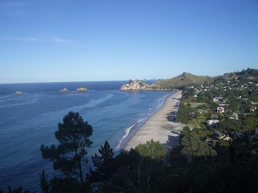
Coromandel Peninsula
In the afternoon I left towards the Pacific coast again and went to
the Coromandel Peninsula. My first stop was at a place called Hot Water
Beach where thermal activity is taking place under the sand. And if you
dig a deep hole during low tide you can have your very own hot pool on
the beach. Arriving in Hahei I was very happy to stay in my tent again
after a couple of days in hostels. |
 |
|
|
| This tiny former fishing village on the Coromandel close to the
famous Cathedral Cove rock formations is among the places with the
highest property prices throughout NZ. If you have got a look on the
photos you can possibly guess why. |
 |
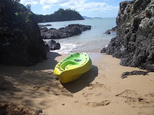
The next morning I went on a sea-kayak tour through the marine
reserve.
We surrounded some islands and surfed waves with our big kayaks
before we were landing on a beach close to Cathedral Cove (next
picture). |
 |
|
|
| I spent the rest of the day relaxing on the beach and cycling along
this magnificent coastline for a bit. Here was the place were both
Europeans in the late 18th century and Polynesians a few centuries
earlier, started to settle the islands of New Zealand or Aotearoa, the
land of the long white cloud, as the Maoris call it. |
 |
|
|
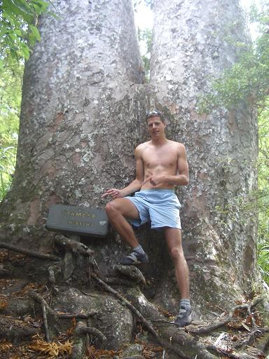
The following day I crossed the peninsula and discovered some of
the last Kauri forests in New Zealand.
These massive, slow-growing trees once covered large areas of the
North Island before mainly European settlers cut them down for timber
and in order to create space for their sheep.
From the west coast of Coromandel Peninsula I was already able to
watch up to Auckland, 60 km away across the sea.
I talked to fisherman in the harbour and asked in the local pubs as
well but there was no way to get there on the water. So I had to cycle
about 200 km on the land route to make it to NZ’s largest city.
Fortunately, on the campsite where I had to stop on the way, they
had discovered a hot spring and so I was able to take a relaxing bath in
water of about 40 degrees next to my tent after a long day on my bike.
What a splurge... |
 |
|
|
Northland
Arriving in Auckland I had 4 days left before my flight departed to
Melbourne and so I left to the far north the following morning. My first
stop was at Pahia in the Bay of Islands. Here me and a guy from the UK
borrowed canoes from our hostel and paddled through the waves of the
bay. However, these dodgy little canoes were not as stable as they
should be for going on the sea. It almost cost the life of my camera
when a wave caught me and sent me over the rocks. Fortunately, I could
stay on top and get away from the rocks to the beach. When pulling my
canoe on shore, I realised that it had put on weight since we left from
Pahia… The reason for that was a hole in the back which slowly
filled it with water… After emptying the canoe on the beach I tried
to make the way back a bit quicker as I did not want to end up as a
submarine… |
 |
|
|
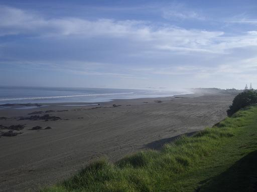
| My last days before heading back towards Auckland I spent in
Ahipara on the Ninety Mile Beach. There I found time to relax and
reflect upon these exciting two months in one of the most beautiful
countries of the world. But, of course, I could not miss out on surfing
the waves which have become famous by the movie The Endless Summer in
the 1960s. It was the perfect end for my longest period of travelling so
far. It has not always been easy, I had tough moments on my bike and
elsewhere and moments where I have been tired of travelling. But every
night I had the feeling that it was worth all the effort of the day. And
now, in the end, I will keep an experience in my mind that will make me
happy, whenever I think about it. |
 |
|
|
The final day in Auckland
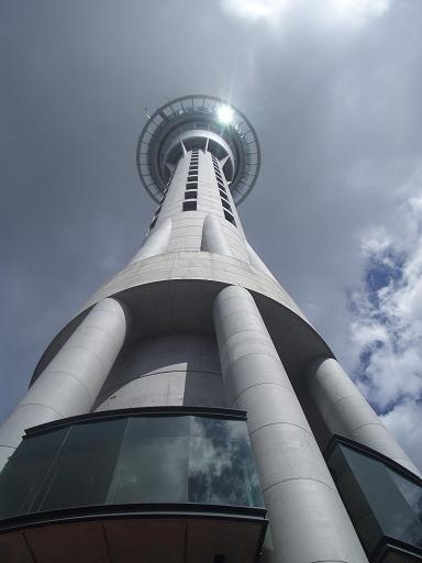
The last day I did some city sightseeing in Auckland. So I started
with the Skytower, the tallest building in the southern hemisphere.
|
 |
|
|
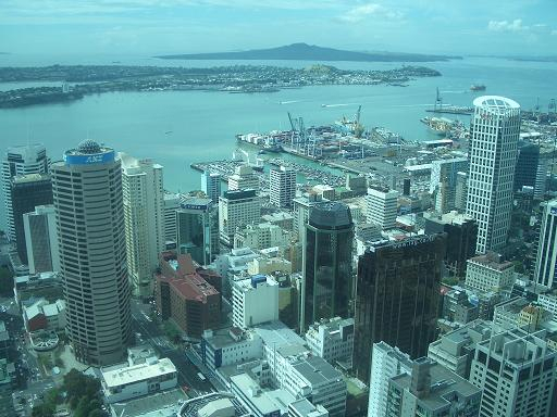
Up there I ws rewarded with some magnificient views over Aucklands
center and the more than 30 volcanoes the city is situated upon.
Finally, I was heading to the airport where it ended the way it has
begun in Christchurch about two months ago: |
 |
|
|
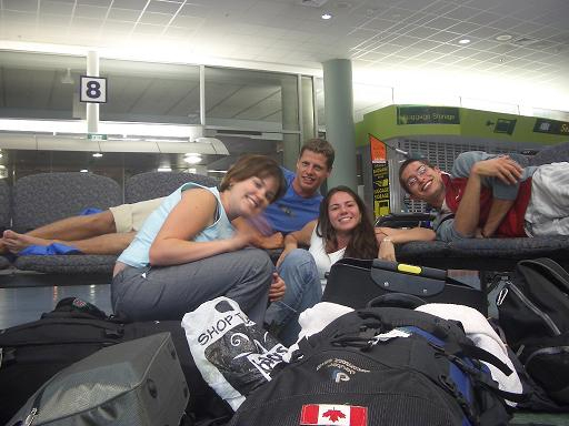
| With a night on the airport. As you can see on the final picture,
it was again a random mix of cultures in our provisory dorm with
backpackers from Australia, Canada, Brazil and Germany. |
 |
| Click here to go back to the South Island |
|