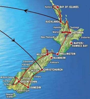
My itinerary for New Zealand
Whenever you are looking for me in February or March, I will always
be somewhere on the red line cycling, walking, climbing, hitchhiking,
swimming, canoeing, surfing, rafting, paragliding or whatever else is
coming into my mind...
|
 |
|
|
South Island
Arriving in Christchurch
After landing on Christchurch Airport at 23:00 I had to realize
that all the backpackers were fully booked. The only room available was
NZ$ 120 which slightly exceeded my budget. So I stayed at the airport
and slept really well behind the Air New Zealand departure desk as you
can see on the first picture. |
 |
|
|
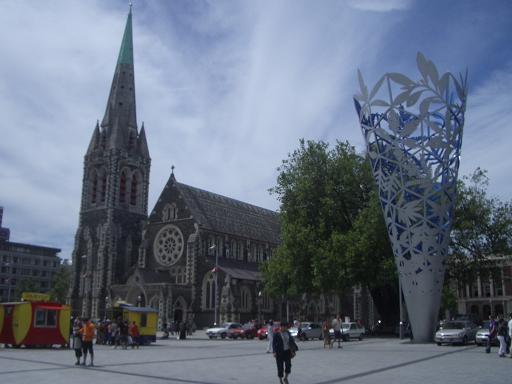
| Having spent nothing for the night I headed towards the
city the next morning and had a first-class breakfast in a nice cafe.
Afterwards I had a short walk through the city in order to find a
suitable accomodation. Although I was successful initially and found a
bed in a hostel, I was a bit disappointed of my first impressions of NZ.
|
 |
|
|
| Christchurch is not an ugly city but it just looks like
an ordinary English town and coming from Melbourne which I really liked
immediately my expectations were too high. But I got everything sorted
out, got a good bike and all the stuff I needed and so the journey was
about to start... |
 |
|
|
The first short trip...
...led me to the Banks Peninsula and offered me some great views
and I found a beautiful place called Sumner which is just outside the
suburbs of Christchurch but directly by the sea. So I decided to stay
here in a very nice hostal close to the beach. The evening and the next
morning I had a couple of surfing sessions and I felt that my holiday
would now really start. |
 |
|
|
By the way, I went again to Christchurch and I have to
admit that it is not as bad as my first impression. There is lots do do
for young people there also seems to be a quite vibrant nightlife in
which I unfortunately could not take part since it was time to leave to
the south.
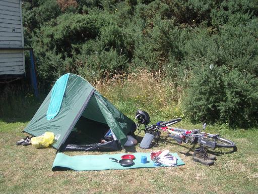
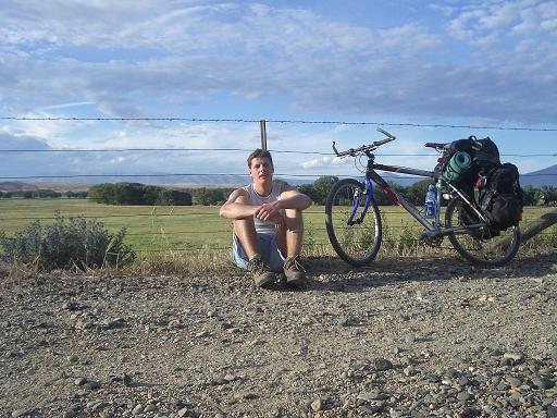
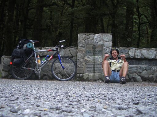
This guy on this picture is quite significant, as his name is
Captain Cook and he discovered New Zealand for the Europeans. So without
him I don't know if I were here. The other thing on the picture is not
less important: my bike which I bought at the Cash Converter`s, a second
hand shop in Christchurch, for about 150 €. It is supposed to get
me up to Auckland in the next two months. Without it I would possibly be
here, but I wouldn't get anywhere else... |
 |
|
|
Dunedin and Otago
I decided to take the bus through the Canterbury Plains up to
Dunedin in the region called Otago. And this was a very good decision as
it saved me many kilometres of boring cycling through the plains. But a
few kilometres before we reached Dunedin the hills and mountains of
Otago began and the arrival to Dunedin in the bright sunshine was just
stunning. A really nice place to be as long as the weather is fine.
The next morning, however, was the worst so far. I suffered from an
ear infection due to too much surfing and too much water in my ear and I
already saw myself taking anti-biotics for at least one week. |
 |
|
|
That would have weakened me so much that I probably
wouldn't have been able to cycle! So, I had pain in my ear and as the
weather was foggy as well I was really pissed off. But as I wanted to
avoid to go to an ear specialist I tried to get the stuff I needed
without a prescription in a pharmacy. And there I was really surprised:
A very helpful pharmacist told me that such infections are very common
and I would not need antibiotics, just normal ear-drops should do it. No
one ever told me this in Germany or France whenever I got this! So I
bought these drops and started to use them and I was ready to go cycling
the next day. And my infection disappeared after a couple of days
without any antibiotics!
But I made some use of my stay and explored Dunedin`s Baldwin
Street and almost made it to the top with my bike. |
 |
|
|
| But I only got there cause some tourists where filming
me and it would have been too embarassing to get off my bike infront of
their camera ;-) |
 |
|
|
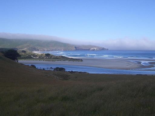
Otago Peninsula
So I went on a daytrip on the Otago Peninsula which resulted to be
the first real highlight of NZ. I just put a few pictures on the website
and I wanna put it in a few words: |
 |
|
|
| I absolutely enjoyed the first night going camping and
staying in my tent and I discovered absolutely beautiful beaches. |
 |
|
|
| Among them I found the beach that you can see on the
picture on the right. And this beach was the one I saw in a
Merian-magazine on NZ approximately 5 years ago in a dark winter in
northern Germany. This picture I always kept in mind and it was the
start for my plans and dreams to travel to NZ! I knew that this beach
was supposed to be somewhere on the Otago Peninsula but I did not know
where and thus it was a magnificient event when I saw it from above.
That made me so crazy that I just went down this steep hill without any
ways or paths and I took my bike with me although it was too steep to
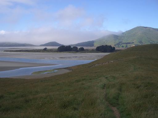
cycle and I was going through a natural heritage area. On the bottom I
had to cross a river flowing into the sea and this turned out to be much
more difficult than I thought, since the river was much deeper than it
looked like from 300 metres above. |
 |
|
|
| And I don't think anybody else has tried to cross it
here cause there where no human footprints at all on this side in the
sand. But as I didn't want to climb up the hill again, I searched and
finally found a place to cross it very close to the sea where it had
already widened up to about 50 metres and so I took my bike over my head
and made it through the river. Thus I reached this wonderful beach which
was worth all the effort I have put in to get there. |
 |
|
|
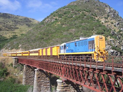
Dunedin to Central Otago
The next day I went back to Dunedin and started from Dunedin
Railway Station, which you can see on the picture. |
 |
|
|
| I took the impressive Taieri Gorge Railway for a couple
of kilometres and afterwards started to cycle on the former rail track. |
 |
|
|
| This track hasrecently been transformed to the Central
Otago Rail Trail with a gravel surface and it is only open for cyclists
and horses. So I took this traffic-free trail for most of the 240 km to
Queenstown. On the way I was putting up my tent on a riverbed and other
places I passed by. This part of NZ is not very dense populated.
Actually, you can only find a place with fresh water (unless you drink
from a river) every 20 km and one day I was going 50 km! before I found
a pub where I could get a cold beer. |
 |
|
|
| But there I also met real native locals whose families
have been living in that region since those settlements have been
created in the gold rush 150 years ago (That is a very long time in NZ).
With one of them I discussed why the hell his ancestors had cut down all
the trees in this area. And not only in the valley, even on the
mountains (sometimes over 1,500 metres high) there was no foerst at all.
Therefore I was exposed to the sun all day long in these dry and
treeless valleys. So I tried to discuss with him where all the trees
went and he only replied that even he has never seen any trees over
here. They must have disappeared 10,000 years ago in the last ice age!
Well, hed did not have to cycle all day to get one pint of beer as he
lived nearby and so he could start drinking a couple of hours before I
arrived and used this time very economically on the glass ;-) |
 |
|
|
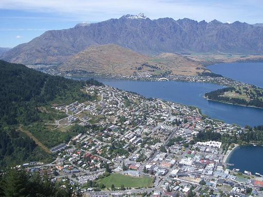
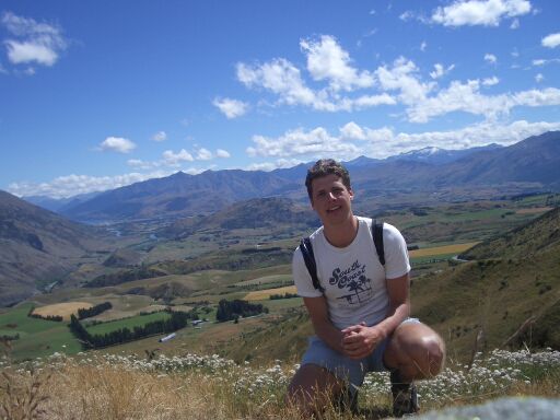
Queenstown
This is where I am (again) and I quite like this place although it
is crowded of tourists. I arrived here after a very hard day on my bike
with headwind all the way. So I didn't want to see my bike anymore for a
couple of days and enjoyed the Queenstown nightlife very much. I met two
guys from Chile and one from Britain and we really had some good parties
over here.
Here you can see the famous panorama of Queenstown and the
snowcovered mountain range of The Remarkables in the background. |
 |
|
|
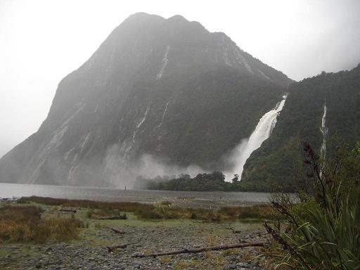
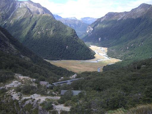
Milford Sound and Routeburn Track
After one of these party nights, however I had to take a bus at 7
in the morning to get via Te Anau to the Milford Sound. Unfortunately I
couldn't take my bike with me as I was planning to hike back on the
Routeburn Track.
Arriving on Milford Sound in the rain was already impressive... |
 |
|
|
...but the next morning in the sun it was just
stunning.
|
 |
|
|
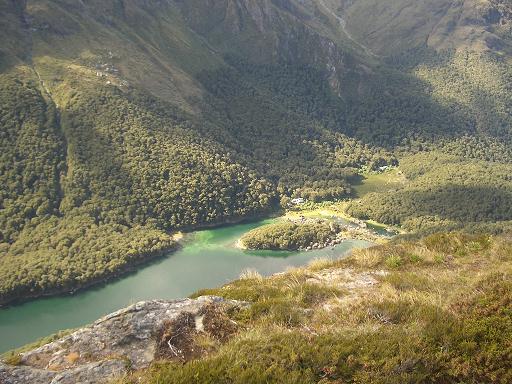
| Such a scenery and diversity of landscape and
vegetation cannot be found in many other places in the world. |
 |
|
|
| On the right side of Lake McKenzie you can see the
first hut and campsite for the hikers. |
 |
|
|
| And here you can see the second one. Anywhere else
along the track camping is prohibited. In order to control the number of
people and the impact on the environnement there is a very limited
number of permits issued for the huts and campsites. |
 |
|
|
| So normally you have to book this track about 4 months
in advance for summer. I have been very lucky to get here since somebody
just cancelled before I went into the National Park office in Queenstown
looking for some hike. |
 |
|
|
Going towards Lake Wanaka and West Coast
Coming back from the Routeburn Track I was Rafting this morning
which was quite expensive but as I've never done it before it was worth
a try. However, it was not absolutely exciting since everybody in the
boat was quite experienced and so the Shotover river was not such a
challenge for us although it is supposed to be quite difficult and
dangerous in some places. But the scenery alone was worth the trip.
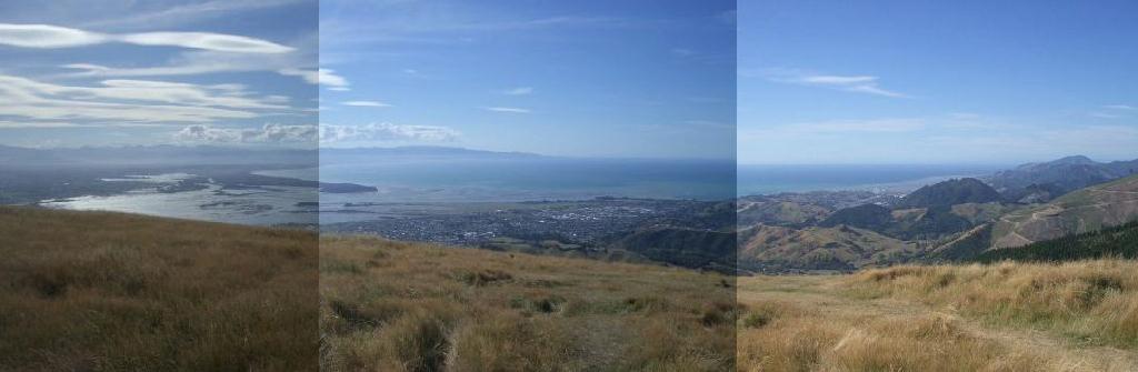
After staying in Queenstown for two more nights, tomorrow I will go
towards Lake Wanaka. This will take me through Wakatipu Basin (on the
picture) an over the highest pass of my tour (hopefully). It will be a
very tough challenge to make it in one day. I hope I don't have to pitch
up my tent somewhere on the way tomorrow evening! |
 |
|
|
| Leaving Queenstown I was really lucky to see a
bus that was heading towards Wanaka. So I asked the driver if he could
carry my luggage and he agreed but I had to pick it up at the bus depot
in Wanaka by 6 o'clock that evening. That meant I was able to ride free
of luggage but I had only about 5 hours to do those 80 km over the
Crowne Range, New Zealands highest pass. But I was doing much better
than I expected and so I was even able to take a lunch break in a nice
pub on the way and still made it to Wanaka at exactly 6 o'clock and got
my luggage and hence I was able to sleep in my tent. |
 |
|
|
| However, the next day turned out to be the
worst I had so far on my bike. Although the road was going along Lake
Wanaka and Lake Hawea (on the picture) all the time it was not flat at
all. It was either going uphill or downhill the whole way. But worse
than that was the fact that I had very strong headwinds the whole day.
Sometimes I felt like I would be standing still on my bike. And I was
really close to just throwing my bike into the lake. |
 |
|
|
| But in the end of the day I did 50 km and I found such
a beautiful tentsite on Lake Wanaka that it was worth all the effort.
You can see this tentsite on the pecs as well, with the snowcovered
mountains in the background. The next day I got up and the strong winds
were still blowing. I didn't want to end up as the day before so I
decided to take a wake-up bath in the lake to improve my blood
circulation. However, the water was freezing cold and all the other
campers in their caravans just thought I had gone mad. I couldn't stay
longer than one or two minutes in the water but when I stepped out I got
a feeling like burning from inside for the next five minutes. And it
really helped and gave me a kick for the whole day. |
 |
|
|
| So despite the unchanged strong headwinds I did much
better than the day before and crossed the Southern Alps at Haast Pass
(picture) and went down to the West Coast. For a lunch break I stopped
at a picnic area called pleasant flat. But despite its name it was the
most unpleasant place I have been to so far. At first I was happy since
no one else was there and I had plenty of space. But as soon as I
stopped I saw the reason why: SANDFLIES! -Actually I have met them
before at Milford Sound and occasionally on the Routeburn Track but
there have always been only a few and I thought all the warnings about
these beasts were just for the tourists to buy loads of insect
repellent- But now at pleasant flat I was immediately surrounded by
hundreds of them. And these nasty beasts don't know any fear. They just
fly to you and bite within a couple of seconds and such a bite feels
like on of a moskito only that it usually stays (and itches) for 4
weeks! If you kill them as soon as they sit down on your skin the next
ones have already landed and even if you can kill 50 of them in a
minute, which is not very difficult, it does not help you since there
are already 100 new ones. So to eat at least a little bit I had no
choice but to pitch up my tent! |
 |
|
|
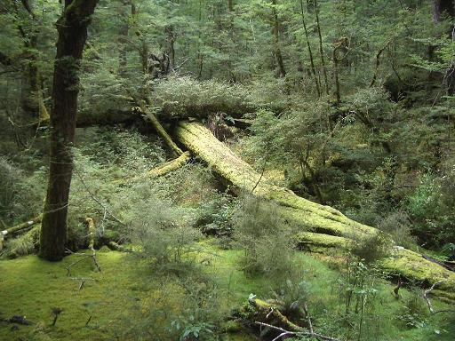
The Wild Wet West Coast
After this pleasant break I went on and had to realise that the
whole West Coast with its rain forests and an annual precipitation of up
to 10000 mm was inhabitated by sandflies. Every time I stopped for more
than 30 seconds they were right there to attack me. Fortunately, they
left me alone as long as I was moving. Again I found a nice place on the
riverbed to set up my tent in the evening. This time, however, it was a
bit dodgy since there were no campgrounds on my way and wild camping in
national parks is forbidden in New Zealand. But I was well hidden in the
rain forest so I didn't get any trouble. The next morning I was shown
why this place is called the Wet Coast as well but the weather changes
quite quickly in New Zealand and so I was able to cycle through bright
sunshine just a bit later.
|
 |
|
|
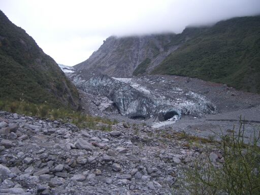
| The next night I stayed on Lake Paringa and the day
after I finally made it to Fox Glacier. This glacier is nice to watch
since it is flowing out of the forest up to about only 300m above
sea-level. But it is alerting to see the marks where it has been only
two hundred years ago: It has been losing about 2 km since then! Global
warming is getting serious. |
 |
|
|
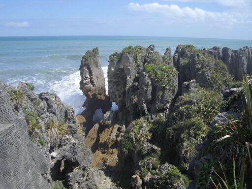
| Until today I totally did about 800 km on my bike and
so I was happy to take the bus to Nelson the next day. After five days
in wilderness I was again looking forward to be back to civilisation. On
the way we passed the beautiful coast of the Paparoa National Park and
the Pancake Rocks (on the photo) and finally made it to Nelson in the
evening. |
 |
|
|
Nelson and Abel Tasman NP
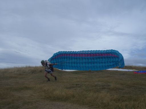
Here I found a very interesting sport I have never done before:
Paragliding. Trust me, this is the most addictive thing I have ever
done. It took me one day of training until I was ready for the first
high flight. You can see my take-off spot on the picture. |
 |
|
|
| We exercised turns, take offs and landing and finally
got even a bit into gliding for a couple of metres. That was such an
amazing feeling that you wanna have it again and again... One of the
first high flights you can see on the pictures. |
 |
|
|
| I was really nervous before and also a bit scared while
flying but gliding down the slopes of Barnicoat Hill like a bird in the
wind is the ultimate experience of freedom... As the wind was quite
strong and gusty in Nelson, the first part of my paragliding license
finally took me a week to complete. |
 |
|
|
| But then it was time to go again and I took a speedboat
across the bay to Abel Tasman NP. There I changed to a smaller boat and
went to Bark Bay (picture) in the middle of the park, next to the Marine
Reserve. Actually I wanted to take a Kayak but I was not allowed to rent
one on my own due to security reasons. That was ridiculous because as
long as you are aware of the fact that you are on the sea and have basic
kayaking skills there is not much that can happen. |
 |
|
|
| So I was going to hike the coastal track back from
where I landed with the boat. After setting up my tent in the campsite I
went for a sunset walk for a couple of km and enjoyed the scenery almost
without meeting people. |
 |
|
|
| This is quite rare in this park since it is one of the
most frequented in summer and so far there is no limitation of tourists
like on the Routeburn Track. The next day I hiked about 20km back to
Maharau at the end of the park and I saw loads of beautiful beaches like
this one at Frenchman's Bay. |
 |
|
|
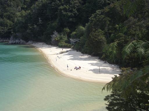
One of the last beaches I passed by on the track was at
Appletree Bay (on the photo). For me it was the most beautiful one I
have seen since Otago Peninsula in the south.
In order to get back to Nelson I decided to hitchhike and Mike, a
Kiwi from Mapua, gave me a lift. We were talking for a couple of minutes
and he told me that he was running some orchards growing apples, kiwis
and other fruits. And then he asked me if I would like to come around to
his place for a beer. I happily agreed and he also gave me a short
sightseeing tour through his village before going home. There we had a
beer and as his wife had cooked I was invited to dinner as well! That
was another great example for the hospitality of the Kiwis. They are so
proud to show you their country and so happy to have tourists around
that this spirit which you can feel everywhere makes travelling in New
Zealand an absolute pleasure! |
 |
|
|
After dinner Mike also gave me a lift for the final
20km to Nelson. There I watched the sunset at Tahunanui Beach and
afterwards pitched up my tent again before heading towards Picton the
next morning...
Marlborough Sounds
On the 120km from Nelson to Picton I had to cross a few passes and
the coastline had much to offer as well so I decided to take more than
one day for this stage. |
 |
|
|
| In the evening of the first day I had some fish n chips
in Havelock. Afterwards I went on along Queen Charlotte Sound to find a
place to set up my tent. So I cycled through the dust hoping to discover
a spot for camping before it became totally dark. As the next official
campground was way to far away I knew I had to somewhere along the road.
But this turned out to be more difficult than I expected since on my
right side the terrain was rising steeply to the top of the mountain
range and on my left it dropped to the fiord. After a couple of kms on
my left I saw a lookout point with a small walk into the bush. I stopped
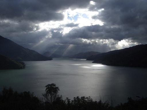
and followed the walk for a bit. Finally, in a small corner I discovered
a tiny spot of maybe two sqm which was just large enough to fit for my
tent. So I set up my tent, opened a can of beer and enjoyed beautiful
views from my sleeping-place. The picture of Queen Charlotte Sound I
have taken the next morning from just outside my tent. It is definitely
one of my favourite overnight stays in NZ. |
 |
|
|
| I arrived in Picton around noon and took the ferry to
Wellington in the early afternoon. It was a nice cruise through the
sounds before crossing stormy Cook Strait and reaching the North Island
in Wellington. |
 |
| click
here to go on to the North Island |
|